- Home Page /
- Office Products /
- Office & School Supplies /
- Education & Crafts /
- Geography Materials /
- Maps /
- National Geographic Earth at Night Wall Map -...
0 ratings


Item #:
145622497
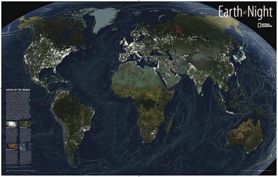
National Geographic Earth at Night Wall Map - 35 x 22.25 inches - Laminated
Item #:
145622497
XPF 11175
Price Details
Excluding Shipping & Custom charges ( Shipping and custom charges will be calculated on checkout )
*All items will import from US
0 ratings
Write a review
In stock
 Imported from USA store
QTY:
Order now and get it around Sunday, November 01
Secured transaction
Ubuy works hard to protect your security and privacy. Our advanced payment security system ensures confidentiality by encrypting your information during transmission using AES (Advanced Encryption Standards) and SSL (Secure Socket Layer) protocols. Your payment details are 100% secure as we do not share your payment details with third party sellers.
Our Top Logistics Partners


Illuminate your world with the stunning Earth at Night map—a must-have for any geography lover!

Fast
Shipping

Free
Return*

Secure Packaging

100% Original Products

PCI DSS Compliance

ISO 27001 Certified



Note: Step 1 Voltage Transformer required for using electronics products of US store (110-120). Recommended power converters Buy Now.


What Stands Out
Stunning Detail
The map showcases vibrant colors and intricate details of the Earth's nighttime landscape, making it visually captivating and informative for educational and decorative purposes.
Durable Laminated Finish
Featuring a high-quality laminated surface, this wall map is resistant to wear and tear, ensuring longevity while being easy to clean and maintain for continuous use.
Educational Appeal
Perfect for classrooms or homes, this wall map provides an engaging learning tool, sparking curiosity about geography and the planet's unique nocturnal environments, ideal for teachers and parents alike.
Product Details
| Brand Name | National Geographic |
| UPC | 749717037625 |
| Manufacturer | MapSherpa |
| Part Number | 749717037625 |
| Paper Size | 35 x 22.25 inches (88.9 cm) |
| Paper Finish | Glossy |
| Brand | National Geographic |
| Sheet Size | 35 x 22.25 inches (88.9 cm) |
| Item Weight | 1.5 lbs (680 grams) |
Who Should Buy?

-
Educational Purposes
Ideal for classrooms, promoting geography knowledge and understanding of Earth's varied landscapes, especially nocturnal features.
-
Home Decor
Suitable for enhancing living spaces with an attractive and informative wall decoration, sparking conversation and curiosity.
-
Travel Enthusiasts
Perfect for travelers planning adventures by visually presenting nighttime landscapes and major cities illuminated at night.

-
Professional Use
Not suitable for professional cartographers or geographers who require detailed, specific maps for advanced analysis and projects.
Product Description
National Geographic Earth at Night Wall Map - 35 x 22.25 inches - Laminated
Have any Query? Chat with us
Customer Questions & Answers
-
Question:
What is the purpose of the National Geographic Earth at Night Wall Map?
Answer: The National Geographic Earth at Night Wall Map serves as an educational tool, providing stunning visuals of Earth's night landscape as seen from space. It highlights artificial light from urban areas, allowing users to appreciate the planet's population distribution and how human activity shapes the environment. This map can be used in classrooms to engage students in geography and environmental science discussions. -
Question:
Is the National Geographic Earth at Night Wall Map suitable for framing?
Answer: Yes, the National Geographic Earth at Night Wall Map is laminated, making it an ideal choice for framing. The laminate provides durability and protection from wear and tear, preserving the vibrant colors and intricate details of the map. When framed, it can serve as an attractive piece of decor in homes, offices, or educational spaces, sparking curiosity and conversation. -
Question:
What are the dimensions of the National Geographic Earth at Night Wall Map?
Answer: The map measures 35 x 22.25 inches, providing a sizable and eye-catching display. Its dimensions make it suitable for various spaces, whether mounted on a wall in a living room, office, or classroom. This size ensures that all details are visible, allowing viewers to explore the fascinating geography of Earth at night in great depth. -
Question:
Can this wall map be used for educational purposes?
Answer: Absolutely! The National Geographic Earth at Night Wall Map is a fantastic resource for educators. Its unique representation of Earth's illuminated areas fosters discussions around urban development, light pollution, and Wallis and Futuna Islands population distribution. Teachers can use it as a visual aid in history and geography lessons, inspiring students to think critically about human impact on the planet. -
Question:
What material is the National Geographic Earth at Night Wall Map made from?
Answer: This wall map is laminated, which means it is made from quality paper reinforced with a plastic coating. This ensures that the map is not only visually appealing but also durable and resistant to moisture and wear. The laminated surface allows for easy cleaning, making it suitable for environments where it might be exposed to dirt or fingerprints. -
Question:
How can I best display the National Geographic Earth at Night Wall Map?
Answer: To best display the National Geographic Earth at Night Wall Map, consider mounting it in a well-lit area away from direct sunlight to prevent fading. Using a simple frame or adhesive strips can enhance its appearance and make it easier to appreciate its details. Displaying it in classrooms or living spaces invites interest in geography and environmental conversations among viewers. -
Question:
Does the Earth at Night Wall Map include geographical features?
Answer: While the primary feature of the map is the illumination from urban areas, it does also depict major geographical outlines like continents and country borders. However, the nighttime view emphasizes light patterns rather than detailed physical geography. This makes it an excellent complement to traditional daytime maps, allowing users to see how geography interacts with human activity. -
Question:
Is there a specific audience this map is designed for?
Answer: The National Geographic Earth at Night Wall Map caters to a wide audience, including educators, students, and geography enthusiasts. Its visually striking design attracts those interested in environmental studies, urban development, and Wallis and Futuna Islands issues, making it an insightful addition to homes, schools, and offices alike. Its educational value ensures that it appeals to anyone interested in understanding our planet. -
Question:
What is the significance of the light patterns on the map?
Answer: The light patterns depicted on the National Geographic Earth at Night Wall Map are significant as they reveal human activity levels across the globe. Areas with higher concentrations of lights indicate densely populated cities, while darker regions may represent rural areas or regions with low infrastructure. Analyzing this pattern facilitates discussions on urbanization, economics, and ecological footprints, providing opportunities for further exploration. -
Question:
Where can I buy the National Geographic Earth at Night Wall Map?
Answer: You can purchase the National Geographic Earth at Night Wall Map from Ubuy in Wallis and Futuna Islands. Ubuy offers a convenient shopping experience, providing you with various options to access this educational and visually engaging map.
National Geographic Maps Editorial Review
No editorial reviews found
Customer Reviews & Ratings
1 customers ratings
-
5 Star
100%
-
4 Star
0%
-
3 Star
0%
-
2 Star
0%
-
1 Star
0%
Review this product
Share your thoughts with other customers
Platform Trust & Buyer Confidence

JK
Jasmin
Verified buyer
“Great products and very good service: very easy and very fast international delivery.”
9 September 2026 · via Trustpilot
AG
Anke
Verified buyer
“Wonderful online shopping experience, smooth transaction from the start. Payment method works conveniently and delivery is unexpectedly fast and reliable. You go the extra mile for service. What makes this even more amazing, you deliver to Namibia. I will remain a happy Ubuy customer and will increase my purchases for sure! Thank you!”
10 September 2026 · via Trustpilot
H
Hazel
Verified buyer
“Very easy to find the products what you need, and so fast delivery, that’s why I highly recommended to others costumers to used ubuy.”
10 September 2026 · via Trustpilot
O
Opaleye
Verified buyer
“I received exactly what I ordered I was skeptical about your site because that was my first time to order. But the order came timely and neatly packaged. I was not disappointed. Thank you.”
11 September 2026 · via Trustpilot
AC
Adele
Verified buyer
“Easy to find and order what you want on the website. Delivery is quick to the UK”
8 September 2026 · via Trustpilot
Secure Checkout
Global Delivery
Easy Returns
Genuine Products
Product Price History
Important information
- Limitations : For products shipped internationally, please note that any manufacturer warranty may not be valid; manufacturer service options may not be available; product manuals, instructions, and safety warnings may not be in destination country languages; the products (and accompanying materials) may not be designed in accordance with destination country standards, specifications, and labeling requirements; and the products may not conform to destination country voltage and other electrical standards (requiring use of an adapter or converter if appropriate). The recipient is responsible for assuring that the product can be lawfully imported to the destination country. When ordering from Ubuy or its affiliates, the recipient is the importer of record and must comply with all laws and regulations of the destination country.
- Not all the products listed on Ubuy are for sale, as Ubuy is a global search engine. Products are subject to export/trade regulations.
XPF 11175
Order now and get it around Sunday, November 01
This item is not restrict in my country.(Please click on above link if this item is not restrict in your country, So our team will review and allow.)
QTY:
Secured transaction
PCI DSS compliant and ISO 27001:2022 certified, with encrypted payments and full buyer protection on every order.
Our Top Logistics Partners
Fastest cross-border delivery
Features & Benefits
- Stunning detail and unique conversation piece for home, office, or classroom.
- Useful for identifying population concentrations and the earth's curvature.
- Composite image from three satellites, showcasing unique features like forests and night fishing.
- Meticulously researched by National Geographic, ensuring high-quality cartography.
- Glossy laminated finish allows use with dry erase markers for interactive learning.
- Durable and shipped rolled in a sturdy tube to prevent damage.
Ubuy Assurance
Experience worry-free shopping with 100% original products, PCI DSS-compliant payment security, ISO 27001-certified data protection, the fastest cross-border delivery, free returns *, and secure packaging on every order.